Showing posts with label hiking. Show all posts
Thursday, September 11, 2025
Hiking to Grand View Point, 2025
Earlier this summer, our Daughter Jen joined us for a hike to Taggert Lake. The next hike on our list, and the most strenuous, was our yearly hike to Grand View Point. It’s listed as an easy hike but at seventy-three, there really isn’t any such thing.
Arriving at the parking lot we put on our hiking boots. Starting up, I asked Renita where we headed and she promptly answered, “To the Top”, (thanks to Steve Gardiner for telling the story in one of his books of hiking with his daughter up Snow king). The first part of the trail had mud puddles, and we realized it had rained shortly before our arrival. We didn’t see any bear prints, always a good sign. Some years we have seen grizzly prints on the trail, so we were carrying bear spray.
As we entered the forest canopy the trail was covered with debris from the rain and the rocks were slippery. Stepping carefully, we avoided any slips and falls, perhaps due to our trek poles. The trek poles give us extra balance as at our age balance is a problem…At one point Renita spotted a flock of Dusky Grouse.
Stopping frequently to catch our breath, we didn’t notice dead trees form beetle kill. Most of the trees looked to have survived the year. The only berries we noticed were snow berries, a white berry that humans can’t eat but one of the foods for hungry bears.
About two thirds of the way up we were passed by a younger retired couple from Pennsylvania as we visited another retired couple stopped on their way down. They were from Virginia. It was like a mini happy hour on the mountain.
We wished everyone safe travels and headed for the top. The forest opened as we approached the top and we stopped for views of Two Ocean and Emma Matilda Lakes. At one of the openings there is an excellent view of the Tetons, almost as good as the false summit.
On the summit we met a family with five kids who ranged from ages ten to two years old. They must have carried the two-year-old girl. The parents had their hands full! They were also on a yearly hike to Grand View Point and like us from Wyoming. On top, three young women from Texas were taking pictures.
The real summit has a sign on it and after some pictures we headed down to the best view of the Tetons and our favorite lunch spot. Some clouds were forming, and I became concerned about the possibility of lighting.
It has happened to me before and it’s not fun to huddle in an exposed position as lighting flashes and thunder booms all around you. (I have been caught three times on mountain tops, twice on Devils Tower and once while on the summit of Darton Peak in the Bighorns.
Hurrying our lunch we headed down. The pace going down was so much easier but we had to stop and rest. It was taking more effort than usual as the rocks under the canopy were still wet.
My legs were feeling like jelly, so we found a tree stump and took a brief respite. The storms moved away from us, and we continued to the car. We had reached the top!
Clear skies
Tuesday, September 3, 2024
Grand View Hike, To the Top, 2024
Each year we try to hike to the top of Grand View Point. The top of the peak, is on the east side of Grand Teton National Park, and is the best view of the Teton’s . Of course, its prime bear territory and so carrying bear spray is mandatory, (about half the people we meet do not carry any).
We decided to make the attempt on our second trip this week to Jackson, Wyoming. This time we got there early so we could buy a luggage carrier for the Suburu. Hopefully we can now pack the car so that we will be able to see out the back window.
The Thule carrier was on sale at REI, and they had one that fit our car. It was an easy install and before long we were on our way to the Grand View Parking Lot. Passing a large buffalo, bison herd, we stopped for a few quick pics of the huge bulls.
Arriving at the parking lot, there were only a few horse trailers and a few small campers, so we parked, geared up, and took off up the trail, (top picture). We immediately noticed how dry the ground was, and that we kicked up dust with each step.
The trail started up and for us anyway got harder. We are both in our seventies and so each year we have to take it easy with quite a few rest stops along the way. We noticed a dearth of any flowers and saw that many of the trees showed sign of pine beetle disease.
Normally the trees can overcome the infestation, if there is sufficient rain, but this year has been abnormally dry, (pictured is one of many dead trees). We quickly reached the sign where the trail divided and now the hike became quite a bit steeper. Resting often, we reached a rock that marks the halfway point, and taking a picture of Renita, we continued up.
Now I would like to mention that quite a few younger hikers passed us as we stopped, but its ok as the only race we have is against our inner voices. They seem to say you are too old for this, but we ignore them and exhort each other to continue.
Finally reaching the place where we could see several people eating lunch, we greeted them and took each others pictures. Sitting down I almost sat on my phone, but Renita reminded me about how much it cost when I broke the glass several years earlier.
We told the others that the true summit was only a short hike away and after finishing lunch we hiked there for the mandatory summit shot. On the way back down, we stopped so Renita could take pictures of Two Ocean and Emma Matilda Lakes. We had made the hike to the summit! Clear skies, and of course, if you go remember, “To the Top!” (thanks Steve G. for sharing your climbing motto).
Saturday, May 11, 2024
Blodgett Point Hike
We took our first hike at altitude. Jen and Eric are careful to watch us and make sure we were not overdoing it. Their first selection was one we have never been on before. It’s a hike to a place called Blodgett Point and looks down on the Canyon hike we took last year.
This year, due to low snowfall, the hike was dry, and was about one and a half miles long, three miles round trip. The total elevation gain was about three hundred feet, which is about half the height of Devils Tower, which I use to rock climb.
We were passed by many others and on the way down a biker was attempting to ride up the trail. Something I will never try! It was a good pick and we will soon be hiking in Grand Teton National Park. Thanks Jen and Eric! Clear skies
Tuesday, October 24, 2023
Yankton, South Dakota
We arrived at our Nancy and Bob's new home in Yankton, South Dakota. They have a beautiful and large apartment in a fifty-five plus complex. After the welcome hugs they showed us where to park in the underground garage and they helped us with our bags. Their apartment has an elevator, which is just what we needed.
The evening was spent in reminiscing about old times, and it was an early night as we were tired from the two days of driving. The next morning, we rested a bit before going on a walk in the park along the Missouri River. We also crossed an old railroad bridge that had an elevated/suspension roadway that had been turned into a pedestrian and bike path.
It felt good to be able to walk again and to stretch out our legs after the prolonged trip. That night Nancy and Bob taught us how to play dominoes, a simple game called chicken foot. The game took quite a while and Nancy could do no wrong. She won five different hands and she easily beat all of us!
The next day they drove us to the Gavin Point Dam. The dam headquarters had exhibits about Lewis and Clark and from the overlook we could see boats lined up, fishing for paddlefish. The paddlefish do not bite and so the people were tossing rigs with treble hooks and sinkers. As soon as the rig hit the water each person would rip their rod upward hoping to snag one of the giant fish, (we never saw anyone hook up with one of the monsters). The exhibits had a mounted golded eagle, an American indian pipe with pipestone from Minnesota, and a bull boat. The bull boat was made from a buffalo hide, (we highly reccomend the new Ken Burns documentary on American Buffalo).
The road crossed the dam to a nice park and campground where we walked along the shoreline enjoying the nice day. One of the boats caught a fish, it kind of looked like a perch, which is great to eat! Finding a nice picnic table, we enjoyed the lunch Nancy and Bob had packed.
That evening we tried another game of Chicken Foot but again Nancy won. We decided that we should rename the game and call it Nancy’s Foot. She said that she had just been lucky, but it seemed to us that we would need another rematch the next evening before we renamed the game.
The next day we had planned on leaving but high winds and rain made us rethink our decision to leave and so we stayed another day and night. As we hadn’t eaten out yet, we went out to eat at one of our favorite fast food places. Culvers. The food was good, but the hot fudge sundae was great, (I have gained back some weight and so ice cream is now pretty much out of my diet).
After lunch we went to the Mead Sanitarium. The first exhibits were dedicated to the nurses who trained and worked with the patients. One exbibit contained a straitjacket, (it made me remember when one of my fellow teachers had a break down and was subdued and hauled away), and another had an exhibit of techniques for lobotomies(barbaric). There were other exhibits including several rooms describing the Lewis and Clark Expedition.
That evening, Bob grilled steaks on his new Ninja Grill! After the delicious supper out came the dominoes. Perhaps Nancy eased off, but I won and Renita came in second. Talk about kind hosts!
It had been a great stop, it always is with friends. They may visit us in Rockport or even come out to Wyoming for some fly fishing and bear watching. Clear skies
Tuesday, October 3, 2023
Hiking to Phelps Lake Fall 2023
Each year we hike to Phelps Lake. This fall we waited a bit too long and due to a bear closure, the short trail was closed and the hike turned into a longer one. It added an additional 1.2miles but it was still an easy hike with only one long hill to climb.
There were warning signs posted as some of the black bears have raided people’s packs and coolers, (idiots had left them unattended, a fed bear is a dead bear as the bear that eats human food, will be captured and euthanized). We did not see any bears on the hike and yes, we always carry bear spray. The first part of the hike was through a section of grass and sagebrush.
Reaching the road, we had to stop for cars, (the Moose Wilson Road). Crossing it we reached the terminal moraine, (which forms the dam for the lake), and it wasn’t long before we reached the moraine damned lake. Taking an adjoining trail, we crossed a bridge and continued around the lake.
Fred and Becky had to leave early but we sat on the edge of the lake and enjoyed the peace and quiet. A pied billed grebe chased minnows and we did see a few rises, (next time up there I am going to take some fishing gear and we do practice catch and release).
It was calm and we were able to take a picture with the mountains reflecting off the lake’s surface. Heading back down the trail we took it slow but didn’t see any wildlife. Just lots of people were heading up the trail. Some of the older people, (younger than us), asked us how far it was and turned around.
Reaching our car our luck was about to change, as we headed from the LSR Preserve to the Moose-Wilson Road. Cars were parked blocking the road, a bear jam! Now usually the bear is hidden from sight in the thick bushes, but this cinnamon black bear was balancing on top of a service berry bush as it devoured the berries.
I was able to park alongside the LSR road and grabbing my camera got great shots of the bear. It ignored all the traffic and people on bicycles. We watched and took about sixty images as the bear seemed to pose offering us both profile views as well as one where it looked at us, (you can see it’s eyes).
We were even lucky enough to get pictures of it as it opened its mouth showing it’s fangs and even a bit of its tongue. The light was perfect, the sun in the right position and the pics are the best black bear pictures we have taken this year, (and we were at a safe distance).
Finally, the bear couldn’t find any more berries and climbed down the tree. It disappeared from sight and the bear jam broke up. We never did see it again, but we were excited that we had been in the right place at just the right time, (Fred and Becky had already left). It was great last hike and trip of the year! Clear skies,
Wednesday, September 27, 2023
Hiking the Taggart Lake Trail 2023
Each year we must hike the Tagaert Lake Trail. Its trail head is easy to find, just drive the Teton Park Road and look for the traffic jam. It’s one of the spots that’s so loved that the parking lot is full before nine am and this day was no exception. Our friends Becky and Fred got the last spot, and we ended up parking alongside the road.
Grabbing our bear spray and day pack, we met them at the trail head and up the trail we went. While we hike a lot, Fred and Becky are in better shape and so we were in our usual position at the tail end.
Becky patiently stopped Fred until we caught up and they only had to stop for us four or five times until we reached the top of the terminal moraine, (that’s the pile of rocks that marks the lowest elevation the glacier reached and forms the dam for the lake.
The lake was perfectly calm, and they shared the above picture of the reflection of the Tetons in the still waters, (Fred posted it on his photo sharing site and at last count he had over five thousand likes, one of his highest totals). There were quite a few other people, and we took turns taking pictures of each other.
Crossing the foot bridge, we parted ways as our friends were on a time constraint, (their dog was at home alone and sometimes has an accident). We loved having our dogs but decided that we will not get another as dogs are not allowed on the trails as they attract bears. Our friends returned down the trail, and we continued up and over the high point. Renita posed at the high point for a picture. The leaves had not turned yet and so the image was not as colorful as last year.
Suddenly we heard an elk bugle, and it was close! Stopping, we scanned the forest but did not see it. Another elk bugled in answer to the first and we hoped to see them fight but we never did. The elk are in rut right now and its one of the reasons we hike the trail, so we can hear them challenging each other.
We passed the spot where in the past, we had encountered a bear. The bear was so close that it almost ran over Fred and he was staking its picture! As usually happens the bear fled when he stood up, he is over six feet tall. If you encounter a bear, get big, always carry bear spray and do not run! We have only been charged once and that bear stopped before we had to use it but still…. Look for the two sets of ears
As we walked along the trail section, we noticed moose tracks. Another hiker told us there was a cow and calf moose very near the trail and sure enough there was a moose jam as other hikers stopped to take their picture. They were too close to the trail for comfort, and so we continued past them before taking pictures. Both were watching us and at one point I thought the cow was going to stand up, a scary thing as moose kill/trample more people than bears.
We finished the hike and Renita saw that Becky had texted us. She wrote that a large bull moose was at our favorite pond and so we drove there to join the crowd. It was where we had seen a bear before but no bears just a bull who was pestering a cow and calf moose.
From there we drove to other bear spots, but we didn’t see any, (our friend Vicky was also looking for bears and ended up taking pictures of three black bears and one grizzly bear! Talk about a lucky day)!
It was time to head home, we could now check the Taggert Lake hike off this year’s list of hikes, to do in Grand Teton National Park. Clear skies
Saturday, September 23, 2023
Hiking to the Periodic Spring. on Swift Creek Trail
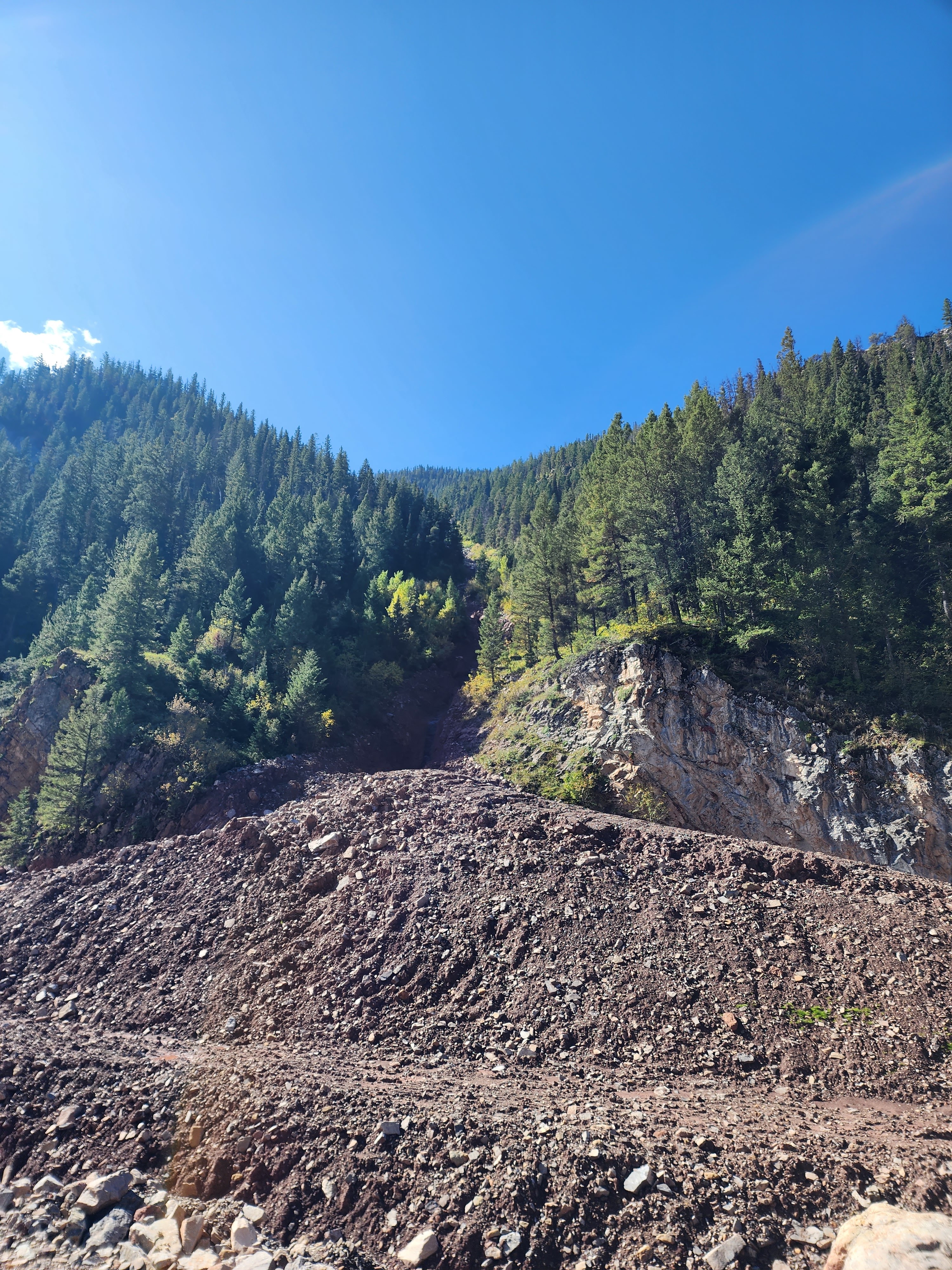
One of our favorite hikes is near Afton, Wyoming. Its name is the Periodic Springs Trail, which is along Swift Creek, (which happens to be the water supply for the town). On or about June 15th, a mud slide started slowly moving down a side canyon but then accelerated when heavy rains caused it to threaten Afton’s water supply, (source Jackson Hole News and Guide).
The mudslide also endangered small two hydroelectric plants and the trail. The town of Afton provided heavy equipment and quickly repaired the damage. While an alternate trail was available, we waited until the usual route was reopened and the repairs completed.
Fred and Becky and their dog joined us for the easy hike, and in several places we could see the remnants of the mudslide. It had poured down a steep and narrow canyon and it had taken quite a bit of work to reroute the stream. The road to the trailhead is filled with large potholes but by carefully picking a line, our Subaru did not bottom out, (our friends were driving their four-wheel drive truck).
There were quite a few vehicles at the trailhead, and I armed myself with bear spray, (the chances of encountering a bear were remote but grizzly bears have been photographed in the area). There were also some unleashed large dog’s, and one of which was a pit bull. Heading up the trail, it’s only three quarters of a mile, we reached the slide and shortly the bridge which spans Swift Creek.
I was the only one who wanted to climb up the trail to the springs outlet as the others had already been there and did not want to traverse the slippery rocks and sandy mud, (we are all over seventy years young).
At first the trail was easy but in places it was gradient increased and so I was forced to fourth class several spots, (fourth class means you use your hands to provide balance and security. As I neared the springs the flow in the creek dramatically lessened and so I hurried up the final bit as the flow almost completely disappeared.
I took a couple of images of the change in volume, as did Renita who was taking pics from below. One of the changes I noted was that the board, which prevented people from entering the spring, had been replaced by brass plates, (during a normal water year the spring completely stops for about fifteen minutes, this is not a normal year).
Heading back down the trail was more challenging than the hike up and in one place my foot slipped but I had firm handholds and safely passed the troublesome stretch. The trail was also more challenging as it was wet and I don’t have the balance I used to have.
I finally reached our group who were taking pictures of the temporally dry stream bed. From there we watched as a group climbed the trail. They did not seem to have any problems although at one point the mother grabbed her two-year-old toddler, (oh to be young again and ignorant of the dangers involved). In a side canyon two others were climbing the cliff face without ropes and at one point dislodged a rock, unaware of an older person sitting below.
No one yelled rock as a climber would do to warn any person at the bottom, and I realized these were either not climbers or people that spent most of their time on manmade climbing walls. We decided to head back down and passed many people starting the hike.
It had been a great day, but I decided I would not hike the wet and slippery trail again. That night I discovered that I had pulled a muscle and could not go down any stairs without pain. (luckily I recovered and four days later was able to hike the four mile Taggart Lake Trail in Grand Teton National Park. That’s the next Blog…… Clear skies
Monday, July 24, 2023
Grand View Point Hike with Jen and Eric, July 9th, 2023
Jen and Eric arrived on Friday the 7th of July. The next day we had our last show of the year at the Barn so while we were busy, they took a short hike up Cedar Canyon. Sunday the 9th our plan was for all of us to hike up Grand View Point Trail, as Eric had never been on it.
The next morning we rode in two separate cars and then met at the headquarters at Grand Teton National Park. Taking the Park Road we told them of the locations where we had seen bears but none were visible. Arriving at Grand View Trailhead we made sure everyone had bear spray and then started our trek.
Knowing that we would slow the youngsters down we quickly fell behind their fast pace. However, they stopped and waited for us after each uphill climb. Renita and I only stopped for about six times to rest before we caught up to them.
Wildflowers were everywhere, always a good reason to stop, and at last we saw Eric standing on the point. Reaching them we took pictures of all four of us. Jen was able to set up her cell phone by resting it on a rock. We were just below the real summit, and we quickly reached the high point for more pics. From that point we could see both Two Ocean and Emma Matilda Lakes.
The youngsters had talked it over an decided to hike down to Two Ocean Lake. From there they would hike to the east side of the lake and we would descend the way we had come. The plan was for us to then drive and pick them up at the Two Ocean Lake Trailhead.
Knowing it would take them awhile we took our time descending to our car. Along the way Renita and I both took images of all the wildflowers, and talked with several families as they passed us. One family had not taken any water with them or bear spray, (they were from overseas and did not understand how many bears, especially grizzlies, frequented this area/trail).
Reaching the car, we headed south past Jackson Lake Lodge and the Oxbow before arriving at the Pacific Creek Road. It was a short drive up the road until we reached the turnoff to Two Ocean Lake. The road got progressively worse before we reached the trailhead.
Jen and Eric had finished the hike about five minutes before we arrived. They had taken the longer trail, about four point three miles. It was mostly an easy grade, but they had felt nervous as they walked past numerous bear scats. There were also sections with high willows which could always hold a bear! No bear ever bothered them, and they were both armed with bear spray.
Living and hiking in the Bitterroot’s and Sapphire Mountains they know to make noise and to keep their bear spray handy. We had planed on eating lunch at the lake, but the mosquitoes had hatched and it was impossible to sit still, so we drove to the beach at Colter Bay, found a table and enjoyed our lunch.
It was a great day with lots of flowers, a fun family hike, and beautiful blue skies. Thanks Eric and Jen for making sure we would safely reach the top! Clear skies
Subscribe to:
Posts (Atom)