Friday, July 28, 2023

Flowers along the tail, pictures by Renita

We took so many pictures of the wild flowers, that we decided to write a blog that is mostly flower pictures. Here they are, in no order.
named firecracker
indian paintbrush, Wyomings State Flower wild buckwheat
cowparsnip
honeysuckle berries-don't eat!
aspen fleabane
wild geranium
clueless, our app ids it as fox and cubs Anyway rocks are a lot easier to identify...Clear skies I would say stop and smell the flowers but we have a plant here named death camas. One bulb is fatal and its often confused with yarrow root which tastes like a wild onion. Death camas is sometimes surrounded by dead insects

Monday, July 24, 2023

Grand View Point Hike with Jen and Eric, July 9th, 2023

Jen and Eric arrived on Friday the 7th of July. The next day we had our last show of the year at the Barn so while we were busy, they took a short hike up Cedar Canyon. Sunday the 9th our plan was for all of us to hike up Grand View Point Trail, as Eric had never been on it. The next morning we rode in two separate cars and then met at the headquarters at Grand Teton National Park. Taking the Park Road we told them of the locations where we had seen bears but none were visible. Arriving at Grand View Trailhead we made sure everyone had bear spray and then started our trek. Knowing that we would slow the youngsters down we quickly fell behind their fast pace.
However, they stopped and waited for us after each uphill climb. Renita and I only stopped for about six times to rest before we caught up to them. Wildflowers were everywhere, always a good reason to stop, and at last we saw Eric standing on the point. Reaching them we took pictures of all four of us. Jen was able to set up her cell phone by resting it on a rock.
We were just below the real summit, and we quickly reached the high point for more pics. From that point we could see both Two Ocean and Emma Matilda Lakes.
The youngsters had talked it over an decided to hike down to Two Ocean Lake. From there they would hike to the east side of the lake and we would descend the way we had come. The plan was for us to then drive and pick them up at the Two Ocean Lake Trailhead.
Knowing it would take them awhile we took our time descending to our car. Along the way Renita and I both took images of all the wildflowers, and talked with several families as they passed us. One family had not taken any water with them or bear spray, (they were from overseas and did not understand how many bears, especially grizzlies, frequented this area/trail). Reaching the car, we headed south past Jackson Lake Lodge and the Oxbow before arriving at the Pacific Creek Road. It was a short drive up the road until we reached the turnoff to Two Ocean Lake. The road got progressively worse before we reached the trailhead. Jen and Eric had finished the hike about five minutes before we arrived. They had taken the longer trail, about four point three miles. It was mostly an easy grade, but they had felt nervous as they walked past numerous bear scats. There were also sections with high willows which could always hold a bear! No bear ever bothered them, and they were both armed with bear spray. Living and hiking in the Bitterroot’s and Sapphire Mountains they know to make noise and to keep their bear spray handy. We had planed on eating lunch at the lake, but the mosquitoes had hatched and it was impossible to sit still, so we drove to the beach at Colter Bay, found a table and enjoyed our lunch. It was a great day with lots of flowers, a fun family hike, and beautiful blue skies. Thanks Eric and Jen for making sure we would safely reach the top! Clear skies

Saturday, July 15, 2023

Chief Joesph Highway and driving thru Yellowstone Park

Having arrived at Cody early, we had another extra day, so we decided to take a drive along the Chief Joesph Highway. It would take us to Cooke City, Silver Gate and then into Yellowstone and the Lamar Valley. From there we would head south at Tower Junction. Lastly, we would head south to the Fishing Bridge and turn toward the East Gate, ending at Buffalo Bill State Park.
Having already driven the Chief Joesph highway before, we anticipated the steep grade to Dead Indian Pass, (ten degrees). Stopping at the pass we didn’t expect to be swarmed by chipmunks looking for handouts. At one point a chip monk tried to jump on Renita’s shoe!
With thought of rabies and black death, from fleas, Renita quickly discouraged them. No handouts from us. Wild animals should eat wild food not processed junk food that people eat. The view from the pass was spectacular. A series of steep switchback after switchback finally promised to take us to Cooke City before we turned to Silver Gate and Yellowstone, (the rule is to not ride your brakes, and to use low gear if you are a big rig. I would not recommend Towing anything up or down this pass). As we continued our drive towards the park, Pilot Peak beckoned.
It’s an example of a Matterhorn type mountain formed when three glacial cirques grind back to meet at a point. Along the way we spotted a Coopers Hawk as it caught a chipmunk and flew to a perch carrying its prey. There it dined on fresh meat. The bird did not like us trying to take its picture and our images were not what we had hoped. Entering the Park, we stopped at a traffic jam caused by mountain Goats high above us.
They were so far away that they were simply small white dots. Moving on we came upon a black bear feeding on the grass in an open field. Black bears can be hard to photograph on a sunny day as the shadows can make catching details difficult.
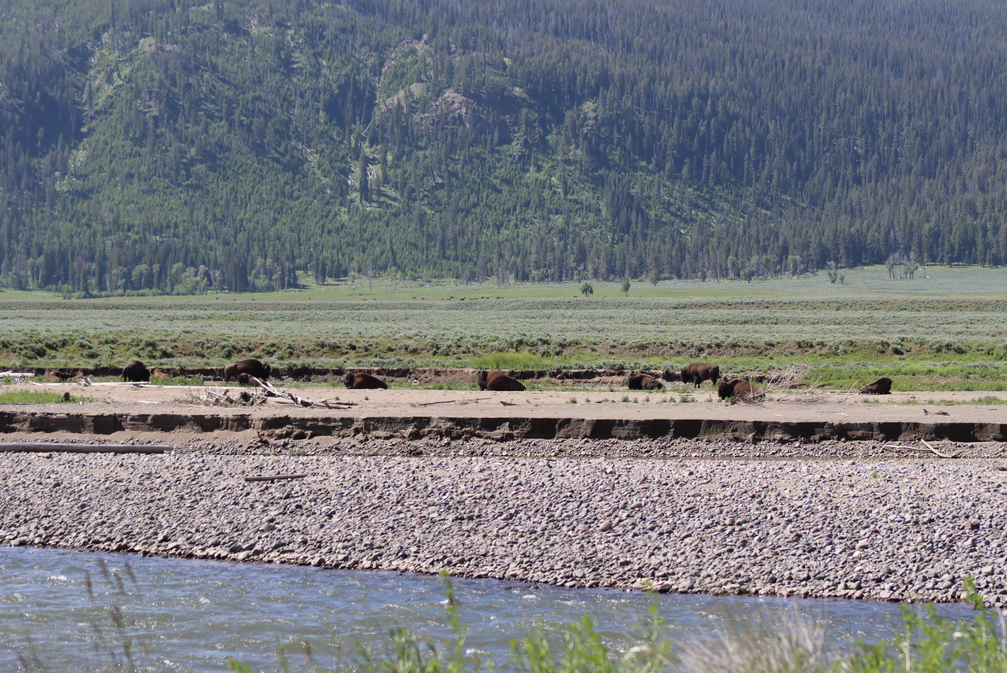
We passed numerous buffalo herds along the way. Many of the turnouts were occupied by bear and wolf watchers who sat in lawn chairs as they waited for an appearance. Almost all had spotting scopes aimed at the distant ridge lines. Last year a massive flood occurred in the Northern part of Yellowstone and in places the road had been reduced to one lane of traffic. In one stretch the Lamar Road had been completely washed away and a landslide had blocked it with a jumbled mess of boulders, mud, and downed trees.
Reaching Slough Creek we took a short gravel road to glass a wolf den but the wolves had already left with their pups, (best time to watch them is in early May and the first part of June as the pack abandons the den when the pups can travel). Crossing one of the most dangerous bridges over the Yellowstone River, (the sides are crumbling). It’s slated to be replaced and work has already started on the new approach but who knows when it will be done, (I try to stay away from politics, but Congress just cut all of the National Parks construction budgets in the latest debt ceiling fight). Reaching Tower Junction, we had just turned towards Tower Falls, Hayden Valley, and the Fishing Bridge, when we ran into two cars stopped and pointing at an animal.
Renita spotted a small black bear and then a large cinnamon black.
A little further she then spotted another yearling cub. We turned around for more photographs and I cursed myself for forgetting our six hundred mm zoom lens. The three bears created a nice traffic jam as they ate grass and clover in along the roadside. I got yelled at by a driver, (saying I was an asshole, but I have been called much worse during my career as a high school teacher), as I stopped so Renita could get the pictures. Four bears in a day!
Rounding a bend four buffalo stood in the ditch alongside the road! We were the first vehicle in line, and they all decided to pass us by walking down the whole road! They were so close that we could have reached out to pet them on either side of our small car, but we know not to pet the fluffy cows! We could see one buffalo’s eyes as it looked at us but luckily decided not to attack our car. It would have made short work of our Subaru Forester. Driving on we climbed over Dunraven Pass, passed Hayden Valley, Sulphur Canyon, and the Mud Volcanoes. Stopping to glass for bears we only spotted more fluffy cows and a few elk. Our next turn was at the Fishing Bridge.
The next stretch was along the northeast shore of Yellowstone Lake, and we again stopped to look for bears. There are several grizzly bears that live along this section of the road, but we never spotted them. Crossing Sylvan Pass, we left Yellowstone Park and finally reached our campsite at Buffalo Bill State Park. It had been a beautiful day with clear skies, great birding, bear watching, and scenic views. We are blessed to live so close to places that are often on other’s bucket lists. Clear skies

Wednesday, July 12, 2023

A short trip up the South Fork of the Shoshone River

We had two extra days before our show setup in Cody, so we decided to explore some new territory, the South Fork of the Shoshone River. Setting out with our flyrods, cameras, binoculars, a picnic lunch and a Wyoming Highway map we felt good. What I forgot to do was to download the Onx hunt map of the river. That would have told us the land status of the area. Driving into Cody we turned right onto Highway 291, (the first part of the expedition was along Cedar Mountain. It was south of us, and it is an area where we purchased rock from a local miner. He has a Variscite claim, and we had bought three pounds at a hundred dollars a pound. Having sold only a few pieces we hoped our exploration would help us with a new story to tell, (It did). After all we don’t sell just jewelry, we sell stories and that’s the key to our success. At first the highway followed alongside the south shore of Buffalo Bill Reservoir, but it turned south and became a road marked as Southfork Road /6WX, leaving Cedar Mountain behind. To our southeast was Carter Mountain and to the north was Sheep Mountain.
Passing public access roads to the mountain and because rain threatened, we decided to pass on the dirt roads, (which were dried muddy ruts, (not good for a low clearance car).
At one point we passed a rockslide that had covered the road but had been cleared and rebuilt. A little further we saw a Historic Marker that told the story of Castle Rock.
It was first discovered and named Castle Rock by John Colter. He was the first white mountain man to explore the area, explore Yellowstone and the Tetons.
It’s one example of a erosional remnant that forms many spires on both sides of the mountains to the northwest.
The water in the river was stained and muddy as a small tributary was pouring mud filled water into the main river. So much for any fly fishing. We also passed signs warning that grizzly bears inhabited the area from April till November, but we never saw any. Small herds of antelopes and several sandhill cranes posed unconcerned by our presence, (it wasn’t hunting season).
The road crossed the river and we decided to turn around. We were close to where the road changed to gravel and then degraded to a four-wheel drive road. If we had our four-wheel drive truck with much higher clearance, we would have continued but I am cautious on first trips on unknown roads.Next was an area called the Ishwood Hills, pictured above. Just over the Mountain was Yellowstone National Park, an area called the Thoroughfare. It is so remote that when in it you are the farthest from any road you can be, when in the lower forty-eight states.
Finally turning around, and it was an uneventful but scenic drive back to our campsite. Now we had new stories to tell. We promise our customers, and all who stop to look at our handmade jewelry that we can tell the story of every stone, (although a few can be a very short tale). Clear skies

Saturday, July 8, 2023

Alpine Mountain Man and Cody Wild West Shows

We only do five shows a year. Two are in Texas, and the biggest shows are in Wyoming. Our Wyoming shows take up three consecutive weekends and so we haven’t had a chance to update our blog. The Wyoming shows are at Alpine, Wyoming, Cody Wyoming, and a small one-day show at the Barn in our RV park.
The Aline Mountain Man Days Show highlights the Native American and Fur Trappers that helped to explore the West. The Native people come form many tribes and dance as the drums beat. The Women Dance and then the children in their beautiful colorful leather, feather, and colorful trade blankets. The children dance in very colorful costumes and seem to twirl like birds with their wings flying, (unfortunately my videos are not sending to our email as they are too large.
The fur trappers wear authentic period costumes which each participant makes. Even the children wear their costumes and some even bring muskrat skins that they have proudly tanned. There are competitions but we didn’t get to watch them as we are trying to sell our Wyoming jade, turquoise, opals, and other fossil and semi-precious stones. The Alpine Show Is three days long and then we have a short break of two days before we head to Cody Wyoming. The reason we have no rest is because it is impossible to get a campsite in the town. Luckily there is a Sate Park Nearby and so we reserved a spot for seven days, three days before the show.
Arriving at our campsite we quickly discovered our campground site was plagued by a family of black billed magpies, (remember Heckle and Jeckle cartoons).
They made cooking almost impossible. Forgetting something every time, I walked back to the camper only to have them land on the table and steal food. We both had to be outside, or the birds would make another raid. Even with the pesty birds we enjoyed a meal along the beautiful lake.
I remembered when our Dad would take us camping and even cook our meals. What happy times they were. Yellowstone National Park was to the west, and we were surrounded by Sheep Mountain, Cedar Mountain, and Rattlesnake Mountain, (some of our jewelry is mined from these peaks).
Besdies the show the Cody Event has three days of parades, and what parades. The largest one was on the fourth of July and include warriors from the nearby Indian Reservations, a unti of the Mounted Marine Regiment from near Washington DC,
and a unit of Hotshot Firefighters, (my brother Mike spent one summer as a member of a federal firre fighting crew in Washinton State),
As we had several extra days before the show, we decided to take two day trips, one along the South Fork of the Shoshone and another traveling by Chief Joseph Highway. These were both beautiful trips and so we took lots of images, which will be in the next two blogs. Clear skies