Wednesday, October 27, 2010

South LLano River State Park

After leaving from Amarillo we headed south to Junction, Texas and South LLano River State Park. There we hoped to spend a few days birding and maybe even floating a part of the rivers. Upon arrival the camping person assigned us to a place that had a low hanging tree branch and so we picked another spot that barely fit our fifth wheel and truck.
Now unfortunately it barely fit both and I had a wheel on the grass, which is a no no as we were soon informed by the park ranger. We next found out that a large part of the park was closed due to the turkey roosting, and I do mean a large part.
That left the bird blinds and so we headed to those. the park has four blinds and like many parks in Texas they actually put out feeders. Its something that is almost never done out west and while I have mixed feelings about feeding wildlife it does bring in the birds.
Cardinals predominated the feeders, followed by black crested titmouse, sparrows and a new bird for us, a grey catbird. At one of the feeders a flock of turkeys snuck up behind the blind but flew wehn we made some noise and so only Renita got to see them.
Another draw for the park is the monarch migration but only a few trickled in while we were there. As much of the park was closed, icluding trails we didn't really do a lot. The river trips were a bit long for us and we couldn't find anyone to share the vehicle dropping off situation so that left hiring a put in and take out sevice.
We never did float the river, nor did we fish. It really wasn't a good time to be in the park due to the closures and if we come back again we will be sure to be there when the areas are all open. Oh yeah, and we won't park on the grass! Clear skies. 

Thursday, October 14, 2010

Amarillo, Flatlands, Canyonlands, and Cadillacs

From Capulin, New Mexico, we headed  south on US 87. As we entered the Texas Panhandle we encountered some of the flattest terrain we have seen. So when we arrived in Amarillo we weren't planning on staying too long, but the rv park had a deal and so we paid for two nights and got the third night free.
As we registered we asked the campground host about things to do in Amarillo and she quickly told us about Palo Duro Canyon, the antique disrtict, and with a grimace the Cadillac Ranch. Renita collected all the info and we decided to head first for the canyon.
Now the Palo Duro Canyon State Park is about 30 miles from our rv park and as we drove across the Texas high plains it seemed unlikely that the canyon could even exist. However as we neared the canyons rim we were treated to a steep sided canyon that reminded us of the Devils Tover area. Entering the park the road quickly warned us to use low gear and  we drove down a really steep and winding road! Definetly not another place that flat landers would enjoy. Halfway down an impatient driver pased us on a double yellow line and just before a hairpin. Must have had an important date with an armdillo?
Stopping at the overlook we enjoyed the view of the Lighthouse, a natural erosional remnant/pillar, and a sweeping panoramic view of most of the state park. A volunteer told us aout the Auodad or Barbary Sheep and so we hoped we could spot some as we toured the canyon.
After the steep and sharp descent we drove along a good road that did dip as it crossed and recrosssed the river. We checked out the first campground and it was very nice but the further campgrounds all presented problems for a stay as we worried about crossing the many river fords. While they probably would be dry the steepness could present the possibility of high centering or at least dragging the rear end.
We stopped at a rebuilt dugout, a partially buried earth home. It looked a lot roomier that Luna"s Jacana at Big Bend National Park. We continued to make stops, looking for the elusive Barbay sheep but they stayed elusive. Renita did spot our first road runner and it was kind of like a welcome to Texas sign.
At crossing number six the river flowed over the road and so we got to wash off the bottom of the truck.
Further down we passed the trails to the Lighthouse and a bicycle trail that and both held promise for a future visit.
We never did see any Barbary sheep but it was midday and as I was missing my siesta we headed back to Amarillo. At least we had seen a neat place and a place worth visiting again the next time we travel through this area.
The next day Renita had scheduled a full day of antiquing and she had also found a rock shop/supply store so we headed there first. We had only planned on a quick stop but the place turned out to have room after room full of rocks and had a gated area filled with piles and drums with just about every kind of rock imaginable.
We had a nice talk with the owner and we did manage to find some rock to buy, some beautiful sowbelly agate,(its called this because it resemblew sliced bacon)< and some India bloodstone. It was a really good price and I thought about going back and buying more but Renita insisted that it was time for antiquing so we headed to that district.
Now the antique shops are all along a single road and so its pretty easy to park and walk from shop to shop. As usual some shops had some really nice items but many had refurbished stuff thst was poorly done or even worse modern stuff made to look like it had some age. We even walked into one shop that didn't have any antiques at all, besdies the owner, and it advertised antiques!
Just when I was about completely disgusted we entered a shop where the owner made custom fly rods. HIs flyrods had handles of exotic woods and stones and even antlers and we talked with the owners for quite a while about thier beautiful work.
Another antique shop and I was about worn out from so much shopping. On top of that the schools(prisons), were getting out for the day and I didn't relish the rush hour traffic so Renita reluctantly agrred it was time to head back home.
A final stop was at the Cadillac Ranch. Its not the one in the movie but an artwork where ten old cadillacs were buried nose down ionto the ground. The cadillacs all point east and have been placed at the same angle as the Pyramid of Cheops.. There is a constant streams of poeple stopping and walking to the site where you are encouraged to spray paint the ever changing art.
Amarillo is  one of those places that we classify as an unexpected pleasure. Its a place where we had fun and its a place where we will spend more time when we pass through again but next time we will bike and hike the canyon.  Clear skies

Monday, October 11, 2010

Capulin Volcnao National Monument

There where days when teaching was so easy that I wondered why they paid me, and then there where days when they didn't pay me enough. One of the easiest days was when I introduced my students to remote sensing and three dimensional imaging. That day I would start them with old stereo images of Capulin Volcano in New Mexico. Even the stoners were enthralled! So one place on my list has always been the Capulin Volcano in Northeast New Mexico. I can now cross that off my list.
We left Cheyenne, Wy, and drove across Colorado and into New Mexico. The drive was not pleasant as the signs, "strong crosswinds and high winds next 15 miles", were only too correct. Never the less as we crossed into New Meciao the winds stopped and Renita soon pointed out ancient lava flows.
Nearing the town of Capulin, New Mexico, we could see the Capulin Volcano off to the north. The next day we packed a lunch and drove up the road, all of three miles, to the entrance of the national monument. The cinder cone volcano is about as perfect a volcano as you will find anywhere in the Untied States.
After visiting the visitor center we drove up the steep road to the summit and the road is not a place to take flatlanders as there are only two guard rails all the way up! We stopped several times to admire the view and during one of the stops we actually saw a raven carrying a snake in its talon.(its the raven on the left and you can see the snake if you zoom in the image).
Reaching the parking lot we grabbed our gear and started up the crater rim summit. Stopping to sightsee and bird watch we saw a pinon jay and a prairie falcon, besides the usual ravens and little grey birds, some kind of junco? A canyon wren did stop to say hello and perched very close to us!
The trail was only a mile long but it did have several steep parts and we both had to stop as the gradient and the altitude, 8100 feet, caused us to pause to regain our breath.
The view along the way was superb! Sierra Grande, an ancient shield volcano, Baby Capulin, another cinder cone, and lava flow after lava flow all were below us. You could easily see the ripple flow marks from the first eruption of Capulin.
I learned a new term, "Boca", which describes a ridge/levee formed when a flow breaks out of the flank of a volcano. You could also see Rabbits Head, and the ancient Raton and Clayton lava flows along with the four recent,( 50000 years ago),distinct eruption flows of Capulin.
After we finished hiking the craters rim we had to descend into the caldera and stand at the vent. Renita so wanted a rock and it was all I could do to remind her that rock collecting was not allowed and that we had enough rocks in our fifth wheel,(We did stop after leaving the park and pick up some volcanic rock from the first eruption).
Now Capulin isn't our first volcano nor the largest, but it was a fine day of hiking and birding and any day spent on volcano is a good day! If you find your self passing this way, we would definitely recommend it. Retirement is so good! Clear skies.

Thursday, October 7, 2010

Salt Lake City, a Tale of Two Churches

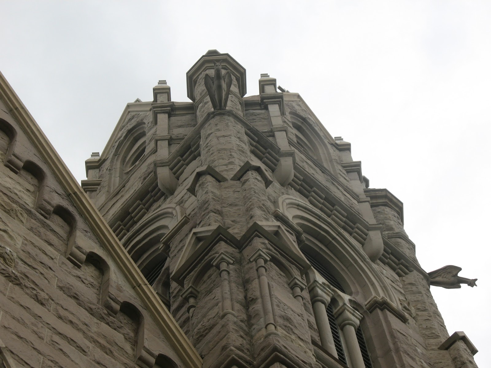
We had a few more days to spend in Salt Lake City, so we decided to visit The Cathedral Of Mary Magdeline and Temple Square. We love to visit churches to study the sytle and art and to get some understanding of each religion. Our first stop was The Catherdral of Mary Mageldine and we were immeadiately captivated by the gothic style of the exterior. Renita pointed out the gargoyles that were on each tower and the intricate carving of Jesus and the Cross greeted us as we walked up the steps.
Inside the church was darkened but the sweeping ceiling and brightly colored pillars told of man  reaching to God. The stained glass windows were as exquiste as any we have seen, including the windows in the Stained Glass Museum at the North Pier in Chiacago. The detail and the number of pieces in each work, along with their colors, told of pieces that were simply priceless. The side altars and front altars were carved from wood and reminded us of the altar in Mesilla, New Mexico. To say we enjoyed the beauty of the church was an understatement.
Leaving the catherdal we headed to the Utah State Capital Building and the Visitor center where we were able to park for free and walk down the steep hill to Temple Square. As we walked we both looked for the temple but it was hidden by the Latter Day Saints World Headquarters Building and it wasn't until we crossed the street that we were able to enjoy the Temple's simply yet towering style.
A church volunteer took our picture by one of the massive doors, built from the old testament specifications of the Temple of Solomon and the lady told us that the interior was only open to those who had earned the honor of partaking in the secret rites/ceremonies/worship. We were confused to say the least.
She further told us that when one was deemed worthy they were given a two year pass that would allow them to enter, and so we looked at the massive building, with its white heavily curtained windows and wondered. At the visitor center they actually have a model of the inside and outside of the temple along with pieces of the same Cottonwood Canyon granite from which the Temple was built.
No crosses adorned the outside, the most prominent feature was the gold figure of Gabriel blowing his horn, calling God's children? We enjoyed the beauty of the outside of the temple and we enjoyed the Latter Day Saints Tabernacle Auditorium but we walked away confused by the secrecy of the place.
It was an interesting day visiting two churches with such different policies, one in which any could enter and view and pray and another in which one had to be deemed worthy. To each their own way to peace and we wish all of you the same peace we have found in our faith. Clear skies.

Sunday, October 3, 2010

Antelope Island State Park, The Great Salt Lake

Across the salt flat, a thin ribbon of water looked inviting but its high salt content held no true promise. Further the Wasatch Front stood and you could see the development as over two million people live along its flanks, yet here we were able to feel the first quiet in our week long stay.
To the west the Great Salt lake stood and we could see Fremont Island and the far distant mountains. Even though we were on the top of Buffalo Point we were still below the level of water that was held by the prehistoric Lake Bonneville and you wondered if the water will ever rise again and fill the basin? Small lizards were everywhere and we were both glad we had made the steep but short hike up Buffalo Point Trail.
We ate lunch at the Buffalo Island Grill and day use area and watched as families parked and walked to the distant waters edge. It was really pretty neat to remember last years travels to Mono Lake and Death Valley.
Large flocks of eared grebes and the largest flock of avocets we have ever seen fed greedily on brine shrimp and the egg cysts that floated on the waters surface. The avocets swung their heads back and forth as if in a feeding frenzy and it was a feeding motion we had never seen anywhere else. Shovelers and California gulls rounded out the bird list and we looked but didn't see the chuckers, even though they were said to be plentiful.
The road to the Fielding-Garr ranch was about ten miles long and as we drove along it I wondered at the families that had settled here and worked such a harsh environment. You could see the springs and their lush greenery that made ranching a possibility but it still had to be such a hard life and a long winter. A large herd of buffalo dominated the landscape although we did see a small herd of antelope and even a wandering coyote.
Driving back down the causeway we stopped at the marina and read the monument to the soldiers who had died here in a tragic helicopter accident. A group of young people from California took turns posing for pictures and they acted like it was a photo shoot for some skin magazine. It seemed so inappropriate for people to act in such a way near such a tragic site.
It had been a really nice drive and we decided that from now on we would rather dry camp at Antelope Island then stay at the rv park in Salt Lake City. Even though there were no facilities or hookups the solitude and  stars would make it possible for us to find the peace we both have searched for during our travels......Clear skies..

Wednesday, September 29, 2010

Fort Bridger, Wyoming

Saying goodbye to Matt and Patty we left Rock Springs and drove all of 77 miles to Fort Bridger, Wyoming and the Fort Bridger RV park. There we were pleasantly surprised as we found a nice and friendly rv park and a State Historic Site that we didn't even know existed/ We also wanted to visit a rock shop in Kemmerer and look for Muddy Creek agates so we parked for three days in a small but friendly place.
We headed to the fort after lunch and because it was mostly outside we were able to take Molly along. We drove there so we could use our state parks sticker and there was actually a gate person who would have charged us had we not had the truck and stickers. Parking our truck,  we headed to the first set of buildings, among which were a school house, a pony express stable, an ice house.
The school house was the first school ever built in the state of Wyoming. I noticed the class size of four was a lot smaller then the 25-30 students I was supposed to teach. The buildings were in pretty good shape and they they were the location of the store operated by the Carter family, the first millionaires in Wyoming.
Many of the original buildings had disappeared when the fort closed in 1890. It was a pretty common tale in Wyoming as when something was abandoned it was usually hauled off for the materials. We did see several old buildings around town that looked suspiciously like buildings in the fort.
Further down we crossed the creek and there the old fort had been reconstructed. The original fort had been burned when Johnsons Army approached in 1857. It had been appropriated by members of the Church of the Latter Days Saints,(there are several different versions claiming legal ownership and sales papers), during the Mormon War.
Inside the stockade we were treated to a demonstration and talk by the volunteer blacksmith. I was surprised by the simplicity and design of the double bellows that fed air to the forge. I wanted to start beating iron but it was not to be. The next buildings we visited  were the museum, officers quarters and commanders house. There we saw the antique love seat that was an identical match to the one that used to be in Renitas family home.
The next day we left for Kemmerer, first getting back on interstae 80 and then heading north through the samll town of Carter, Wyoming. Just north of Carter we found the agate site but didn;t stop as we were going to return the same way. A little further down the road we were halted by a cattle drive of about 100 cows and calfs and three cowboys and cowgirls. It seemd like a commercial from the Wyoming tourism board as so we stopped and waited while the cattle were pushed past us.
Arriving in Kemmerer we found Bobs Rock shop. Bob's speciality is local petrified wood and he has about as fine a display as we have seen anywhere. We discused methods for removing rind from Blue Forest Wood and so now we have heard of four different methods from four different collectors.
Unfortunatley Bob chained smoked and we left the shop smelling like we had been in a bar or casino, but it was still worth the visit to see such a fine collection,(He has the largest blue forest tree and root ball specimen we have seen so far).
Heading back to Carter we met the cattle drive and were led through the herd by a cowgirl who shook a pop bottle full of rocks.  As antelope hunting season is in full swing and we heard shots as we stopped at the agate site so we donned orange headbands. We actually found some interesting agate, at least enough for several tumblers and so we drove the rest of the trip back home happy that we had moer rocks for the fifth wheel,(by the way I did weigh the rig and we can still hold another ton of rocks).
We enjoyed our trip to the fort and a brief view of life on a fort during the 1880's. The rock shop and agate hunt was also another good excursion. If you are ever on interstate 80, crossing the high desert, you might consider staying a couple of nights at Fort Bridger. Clear skies.

Tuesday, September 21, 2010

Seminoe Resevoir and the Miracle Mile

Seminoe Reservoir and the Miracle Mile are two places that are definitely out of the way. Located about 35 miles north of Sinclair, Wyoming, off Interstate 80 you really have to want to go there and so they both are places seldom seen by most people. Renita had never been to Seminoe Reservoir or the Miracle Mile and so we decided to go there do a little sightseeing, maybe cast a fly or two, and most definitely look for more rocks!
So we loaded up the picnic basket and the dog and headed out, accompanied by the every present Wyoming wind and I had mixed feelings about the whole trip. See I had fished Seminoe for six years competing in walleye tournaments and while we had won it and the team of the year it was one of the hardest and most challenging places to fish I have ever been,(The first year we fished it we caught seven walleyes in 6 days and five of those were the first day prefishing. The year we won it we caught four walleye but two of them were 31 inches long!)
The drive from Sinclair, north to Seminoe was really pleasant. Antelope and deer grazed along the road, even though hunting season was on and the river called to me to stop and cast a wet fly and so the thirty miles passed quickly. I pointed out the huge sand dunes, which really are a part of the sand dune field that stretches all across central Wyoming. It is missed by Interstate 80 and so most tourists have no idea of the size of the desert in Wyoming.
Driving into the North Red Hills campground we looked at the pull throughs and they most definitely were large enough for our fifth wheel and so we snapped some images and put it on our list of places for future stays. Continuing on we climbed a steep hill and pulled over at the dam overlook, where we were rewarded with the promised view of the dam far below.
The road quickly deteriorated and we bounced down about as washboard a road as you could find anywhere. Renita pointed out a sign that said the road did not meet public standards which was really a disclaimer by the powers that be that they didn't want to maintain the road.
We reached the bottom and then passed up and over the Seminoe Mountain, finally reaching the area called the Miracle Mile.
Now the Miracle Mile is really a five mile stretch of the North Platte river that runs between Kortes and Pathfinder reservoirs and got its name from the blue water quality fishing for brown, rainbow and cutthroat trout. Well know by any fly fisherman its one of those places where the trout population reached over five thousand fish per mile and so I couldn't get my fly rod out fast enough, knowing that the fish would jump all over my flies!
Renita and Molly took off up the hill, looking for rocks as I made my first cast and then another. Nothing happened? Maybe if I tossed over there or perhaps there and I congratulated myself on the roll casts I made as the two flies and strike indicator made drift after drift.
The fish seemed to have developed a severe case of lockjaw and so I moved up stream. Again I cast and re cast, but the only excitement was the snake that moved next to my foot. Screaming a bit, I don't like unknown snakes next to my foot, I called to Renita to warn her of the reptiles presence but she told me that she had heard my initial yelp. I hadn't realized that I had shouted that loud and it was really just as scary for the snake as it crawled into the tall grass as I carefully skirted around it.
Rejoining Renita and Molly, Renita showed me the green rocks she had collected, jade perhaps, and I decided that the fish were being too snobbish for me to waste time fishing and so I started to rock hound.
However no jade boulders or cobbles or even pebbles jumped out and so we got back in the truck to drive back to the lake for lunch.
I turned down the four wheel drive road to Sunshine Beach and besides some seagulls we had the area to ourselves. Renita found some fossil shells along the beach and I showed her some sandstone ripple marks from an ancient ocean beach.
We relaxed and strolled along the shore and it was really nice to be able to show Renita the sights of a place where I had fished so hard, a place filled with its own beauty, and a wild sandy place so typical Wyoming.
The drive back to Rawlins went quickly and the local rock shop was open so of course we had to stop and admire the jade. I was pleased that I hadn't brought much money and so we left with three small slices that demanded we buy them. Clear skies